Submitted by Pradyut@solver2021 (School Solver User) After the emergence of the Covid-19 pandemic along with many other sectors, the sector of education is dramatically changing. More students are now attracted to the assistance of online tutors. School solver is such a platform that connects tutors with students to help them with their homework, assignments, and projects. School Solver is currently recognized not only as the best tutoring platform in the USA but also of the entire world by a huge portion of students and tutors. It is a platform for many expert tutors with providing them regular staple income. Here is the complete guide if you want to become a School Solver tutor. Requirements to become a School Solver tutor Anyone can register as a School Solver tutor but to provide answers to the questions asked a tutor must pass School Solver Rules and Basic English quizzes. Through this process, the platform makes sure that only dedicated, serious, and qualified persons can become...

Geography of USA
A Business Insider report has been published, regarding geography of U.S.A. under the headline, “Even the US government can't agree on how to divide up the states into regions.” The report states, “The United States is divided into many different regions and subregions - and not everyone agrees on where each state falls. The United States is an enormous country comprising several different regions and subregions. There are countless ways to divide the US on cultural, geographical, and even racial lines. There are so many ways, in fact, that different government agencies all seem to have different ways of doing it.”
GEOGRAPHY OF U.S.A. | Simplest Physiographic Divisions of the United States
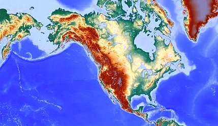
In the simplest form we are able to create eight to eleven physiographic divisions for USA on the basis of greatest geographical landmarks. Dividing USA into eleven physiographic regions is useful to know the geography of contiguous United States, while entire USA can be dived into eleven geographic regions.Eight Geographic Regions of USA
Atlantic Coastal Plains
Appalachian Mountains
Mississippi River and Great Lakes
Great Plains
Rocky Mountains
Great Basin
Sierra Nevada and Cascade Mountains
Pacific Coast
Eleven Geographic Regions of USA
- Atlantic Coastal Plains.
- Appalachian Mountains.
- Mississippi River and Great Lakes.
- Great Plains.
- Rocky Mountains.
- Great Basin.
- Sierra Nevada and Cascade Mountains.
- Pacific Coast.
- Intermountain, that includes Alaska separately.
- Pacific Islands, that includes island state of Hawaii and other territories.
- Atlantic Islands, that includes Puerto Rico and other territories.
GEOGRAPHY OF U.S.A. | Geographic Regions of United States according to Census Bureau
According to U.S. Census Bureau, the country has four major regions, that includes nine divisions, fifty states and the District of Columbia. Each of the regions is divided into two divisions except one region having three divisions.GEOGRAPHY OF U.S.A. | Commonly Mentioned Geographic Regions of United States
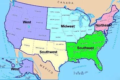
In a popular and common way U.S. geographic regions may be divided into five regions. This categorization is not only popular among general public, but also mentioned by National Geographic Society as geographic regions of US. However some border states may appear in different regions depending on the document or map you are looking at, because of the fact that these aren't officially defined regions. The regions are:-- Northeast U.S.A.
- Southeast U.S.A.
- Midwest U.S.A.
- Southwest U.S.A. and
- West USA

Northeast
Northeast U.S. States includes: Maine, Massachusetts, Rhode Island, Connecticut, New Hampshire, Vermont, New York, Pennsylvania, New Jersey, Delaware and Maryland.
Major geographical features: Appalachian Mountains, Atlantic Ocean, Great Lakes.
Natural Wonders Northeast US: Thunder Hole, Gulf Hagas, Chimney Pond, White Arch at Natural Bridge State Park, Aquinnah Cliffs, Monument Mountain, The Long Trail, Kent Falls, Block Island, Flume Gorge and others.
Major geographical features: Appalachian Mountains, Atlantic Ocean, Great Lakes.
Natural Wonders Northeast US: Thunder Hole, Gulf Hagas, Chimney Pond, White Arch at Natural Bridge State Park, Aquinnah Cliffs, Monument Mountain, The Long Trail, Kent Falls, Block Island, Flume Gorge and others.
Southeast
Southeast U.S. States includes: West Virginia, Virginia, Kentucky, Tennessee, North Carolina, South Carolina, Georgia, Alabama, Mississippi, Arkansas, Louisiana, Florida.
Major geographical features: Appalachian Mountains, Atlantic Ocean, Gulf of Mexico, Mississippi River.
Natural Wonders of the Southeast United States: Hot Springs National Park, Mammoth Cave, Rock City Gardens, Great Smoky Mountains, Everglades National Park, Gulf Coast Beaches, Cape Hatteras National Seashore, ACE Basin, Blue Ridge Mountains, the Ozarks, Avery Island and others.Midwest
Midwest U.S. States includes: Ohio, Indiana, Michigan, Illinois, Missouri, Wisconsin, Minnesota, Iowa, Kansas, Nebraska, South Dakota, North Dakota.
Major geographical features: Great Lakes, Great Plains, Mississippi River.
Natural Wonders Midwest: Cave-in-Rock, Wildcat Canyon, Apostle Islands, Cave of Mounds, Eagle River Chain of Lakes, Maquoketa Caves, Crystal Lake Cave, Seven Pillars, Badlands National Park, Dells of the Wisconsin River, Chimney Rock, Rock City, Theodore Roosevelt National Park and others.
Southwest
Southwest U.S. States includes: Texas, Oklahoma, New Mexico, Arizona.
Major geographical features: Rocky Mountains, Colorado River, Rio Grande River, Grand Canyon, Gulf of Mexico.
Natural Wonders of the Southwest: Big Bend National Park, Guadalupe Mountains National Park, Caddo Lake, Gloss Mountains, Tent Rocks, Capulin, Shiprock, Rio Grande Gorge, Antelope Canyon, Havasu Canyon and Falls, Carlsbad Caverns National Park, Sedona, Monument Valley, Lake Powell, Canyon de Chelly, Grand Canyon, White Sands National Park, Great Basin National Park and others.
West
West U.S. States includes: Colorado, Wyoming, Montana, Idaho, Washington, Oregon, Utah, Nevada, California, Alaska, Hawaii.
Major geographical features: Rocky Mountains, Colorado River, Sierra Nevada Mountains, Mohave Desert, Pacific Ocean.
Natural Wonders of the Western US: The Garden of the Gods, Trappers Lake, Yellowstone National Park, Grand Teton National Park, Thermopolis Hot Springs, Devils Tower National Monument, Lewis and Clark Caverns, The Medicine Rocks, Bruneau State Park Sand Dunes, The Great Idaho Rift, Mount Rainer National Park, Crater Lake, Mount Hood, Arches National Park, Zion National Park, Bryce Canyon, Rainbow Bridge, Goblin Valley, Valley of Fire State Park, Red Rock Canyon, Sand Mountain, Lake Tahoe, Amboy Crater, Death Valley, Badwater, Mojave Desert, Racetrack, Vasquez Rocks, Devils Postpile, Fossil Falls, Pfieffer Beach, Half Dome, Waimea Canyon, Hawaii Volcanoes, Entire State of Alaska and others.
GEOGRAPHY OF U.S.A. | Scholarly Categorization of US Physiographic Regions
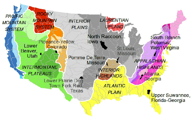
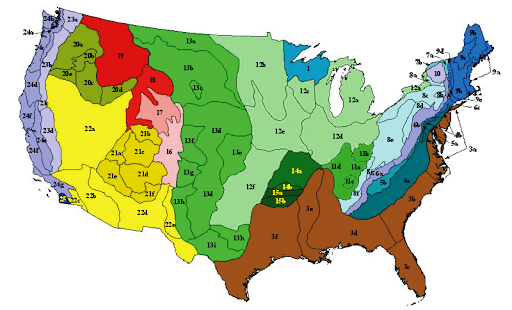
In 1917, a paper of geologist Nevin Fenneman was published, entitled "Physiographic Subdivision of the United States". He dedicated almost all of his scholarly life in researching and presenting his system to establish a scientific but simple categorization for U.S. geographic regions on physiographic terms. The process was resulted in his two books:-- Physiography of western United States; published in 1931 and
- Physiography of eastern United States, published in 1938.
- Anderson, Ewan W. (2003). International Boundaries: A Geopolitical Atlas. Routledge: New York. ISBN 9781579583750; OCLC 54061586.
- Charney, Jonathan I., David A. Colson, Robert W. Smith. (2005). International Maritime Boundaries, 5 vols. Hotei Publishing: Leiden.
- Fenneman, Nevin M. (January 1917). Physiographic Subdivision of the United States. Proceedings of the National Academy of Sciences of the United States of America.
- Brown, Ralph Hall, Historical Geography of the United States, New York : Harcourt, Brace, 1948.
- Physiographic Regions. United States Geological Survey. April 17, 2003.
- Fenneman, Nevin Melancthon (1931). Physiography of western United States. McGraw-Hill.
- Stein, Mark, How the States Got Their Shapes, New York : Smithsonian Books/Collins, 2008. ISBN 978-0-06-143138-8.
- Fenneman, Nevin Melancthon (1938). Physiography of eastern United States. McGraw-Hill.


Comments
Post a Comment